
STORMS UPDATE: A WEEK OF STORMS FOR BAY AREA, NORTH BAY
Although the forecast models have backed off just a bit on rainfall totals for the North Bay, this week looks to be wet and stormy overall. The good news is that rainfall rates and storm timing suggest that beneficial rain will come without major flooding or hydrological issues. BIG snows will fall in the Sierra, and it looks like our stormy pattern may be locked in through the end of the month.
TUESDAY THROUGH THURSDAY
The first in series of waves moved into California Tuesday. (Image 1) Rain arrived in the North Bay Tuesday early afternoon. (Image 2) Expect light amounts of rain by early Wednesday. (Image 3)


Hot on the heels of Tuesday’s storm, a 2nd storm will drop in from the north late on Wednesday and last through much of Thursday. (Image 4) This storm should add about another inch to our North Bay rain totals. (Image 5)


FRIDAY THROUGH SUNDAY – CHRISTMAS OUTLOOK
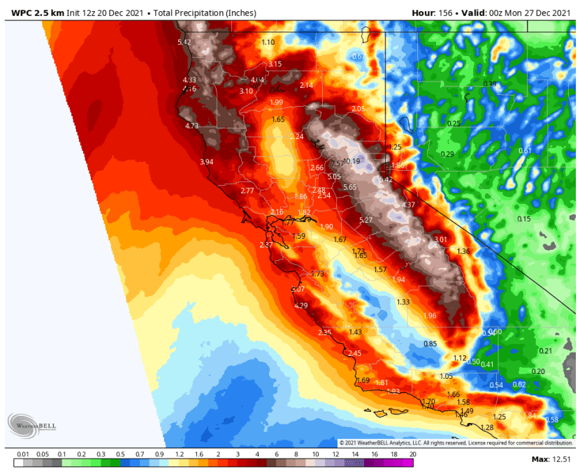
Although rain and showers will be almost non-stop after Tuesday, Friday may be a transition day, with a bit of a break. By late Friday however another storm will drop down along the Pacific Northwest coast, gathering moisture. If you’re traveling on Christmas Eve or Christmas Day you should expect stormy weather. (Images 6-7) Waves of cold air and moisture should continue through Sunday the 26th, with few breaks. By late Sunday rainfall totals for the week may look like this. (Images 8-9)


BEYOND SUNDAY THE 26TH
There are increasing signs that a trough of low pressure will be dominant over California through the end of the month. (Image 10). Blocking highs to the east and west may lock the pattern in place. We may see another round of (potentially big) rain on Tuesday the 28th or Wednesday the 29th. (Image 11)


Low pressure looks to be relatively dominant over the West Coast right into early January. (Image 12) Confirming this trend, the European weeklies keep us wetter than average through the 3rd. (Image 13)


Signs are we will stay cooler than normal through early January. (Image 14)

SNOWFALL IN THE SIERRA
Lots of people will be venturing into the Sierra for skiing and other snow play during the Christmas to New Years period. Check Cal Trans for the latest highway information
https://roads.dot.ca.gov/roadscell.php
By late in the week snow will begin piling up and some of the biggest snows will take place from Christmas Eve through the weekend. Here are the estimates for snowfall by late in the coming week for the central Sierra (Image 15), Palisades Tahoe Ski Resort (Image 16) and Soda Springs at Donner Summit. (Image 17)


We’ll keep you updated on the North Bay forecast as the storms continue through Christmas Week.


Recent Comments