
Pattern Change with Rain on the Horizon for Northern California
A long-awaited pattern change is likely to bring the first in a series of low pressure systems, and the first significant rains of the season, to large areas of Northern California in about a week.
The upcoming pattern change has shown up in the long range models for quite some time, and now is within range of the deterministic models. The good news is there is general agreement among the forecast models in the overall outlook, if not some of the details.
As winter approaches the polar jet stream is strengthening and pushing south, and the first low pressure trough is forecast to dig south to Northern California by around Saturday the 22nd, or Sunday the 23rd.
If you like this content please consider joining 10s of thousands of others in becoming an email subscriber. That way you’ll have the latest weather and climate discussion delivered straight to your inbox!
Just look for the box that says EMAIL ADDRESS at the top right side of this page on your desktop, or directly under comments on your phone.
And, by the way, we never share your email address with anyone. Ever.

This digging trough is forecast to pull the jet stream south into Northern California.

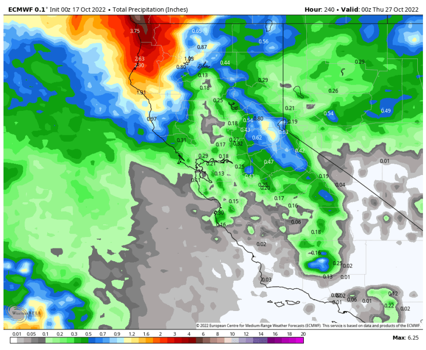
The models agree rain will arrive across Northern California around the 23rd. The higher resolution European model is pretty bullish on two periods of rain or showers from the 22nd-25th.


Although the GFS forecast model generally agrees in the pattern change, it keeps the rain to our north (for now), which is refected in the projected rain totals from each model (Euro and GFS) by November 26th.

The models suggest this first brush with rain is just the beginning of a showery period that could last into the first or second week of November.
Here are the long range outlooks for additional rain by November 7th on both major forecast models.


So the overall message is that light to moderate rainfall is likely to arrive across the North Bay in the next 2-3 weeks.
What about the long range outlook further into November? Again, this is where the long range versions of the models diverge somewhat, with both ensemble models showing potentially significant rain, but the European once again a bit wetter than the GFS.


We’ll see how all of this plays out. One other positive sign from a wildfire perspective is that no sustained heat ups are forecast over the next couple of weeks across Northern California. Good news! Stay tuned for updates.


Recent Comments