
NORTH BAY RAIN, YES. BIG STORMS, WELL…
THE BIG PICTURE
If you’ve been following our posts, you know that this coming week’s weather has been giving forecasters fits. From a powerful storm plunging directly into California, to that same powerful storm staying out in the ocean, we’ve seen a gradual evolution toward drier conditions across NorCal.
We are still going to get some rain, but most likely not as much as we’d first hoped. Let’s get into the details.
THE DETAILS
In meteorology, a couple hundred miles can make a big difference. And, in terms of the California forecast for the coming week it has been the difference between a pretty big storm, and a fairly moderate one. As you can see, a deep low pressure trough is still forecast to drop south, by Tuesday setting up impressively just west of the Bay Area.

But while a few days ago all weather models forecast this deep low to move inland, bringing heavy rain, it is now expected to pretty much stay in one place for a few days, sending off disturbances that WILL bring us rain, but not the drenching we expected. The heaviest rain will stay offshore.

So, what’s going on?
THE REX BLOCK
What the models didn’t pick up right away was the developing Rex Block pattern along the West Coast. This can set up when a deep low forms south of a strong high pressure system. And, often high pressure sets up to the east as well.
You can see this in the image below. The low pressure system is essentially locked in place, or “blocked” from moving east until something changes. The flow forms something of a backward “S” pattern.

WE STILL GET RAIN
So, the low pressure system will be locked to our west, but we’ll still get rain at times here in the North Bay. Most models show disturbances being spun off the low every day or two through the week, bringing us showers that will add up by the weekend.
The first may come late Monday or early Tuesday.

Then another during the day Wednesday, continuing into Thursday. And, most likely, another on Friday as the low shifts south.


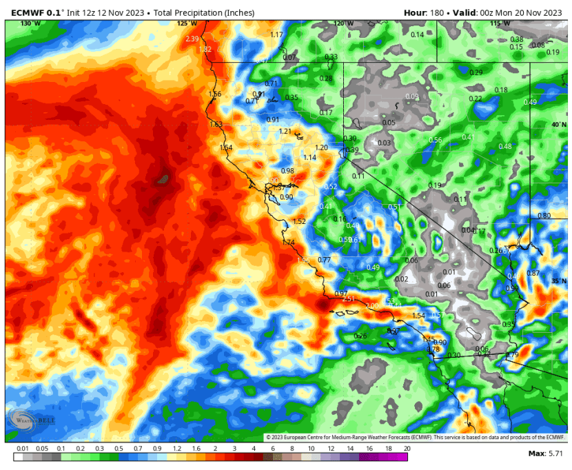
Rainfall by Saturday should still add up to about 1-3 inches across the North Bay. The WPC forecast seems to be pretty much in the middle of the range of possible outcomes, so we can take this as a rough guide.

By Saturday this low pressure center will weaken and finally eject east over Southern California, breaking the Rex Block.

Pretty much the entire state can expect some rain this week. Just not as much as we first expected.
THANKSGIVING WEEK FORECAST
Right now there is uncertainty about the start of Thanksgiving week. The latest European model has another storm brushing us, bringing a few showers on Monday and early Tuesday. Other models haven’t picked this up yet. We’ll see.

However by Thanksgiving Day a push of cold air will drop south over the West, bringing cooler than normal weather. We should expect mostly dry weather, but cool for Thanksgiving Day with highs in the upper 60s to low 70s.


We’ll post more updates as needed in the coming days.


Recent Comments